MyTrails
MyTrails is a comprehensive mobile application designed for outdoor enthusiasts, offering robust GPS navigation, offline map support, and detailed route planning. It caters to activities like hiking, cycling, and running, emphasizing data privacy and community-driven mapping. With features such as POI management and data export, MyTrails enhances outdoor adventures.
About MyTrails
Explore the Outdoors with MyTrails: Your Ultimate Navigation Companion
MyTrails transforms your mobile device into a powerful outdoor navigation system, meticulously crafted for adventurers, hikers, cyclists, and runners. This application goes beyond basic map viewing, providing an intricate suite of tools to plan, execute, and review your outdoor activities. Built upon the foundation of OpenStreetMap, MyTrails offers unparalleled detail and community-driven accuracy, ensuring you have the most up-to-date information at your fingertips.
Key Aspects of MyTrails:
- Advanced Offline Capabilities: A core strength of MyTrails is its ability to operate fully offline. Users can download maps for specific regions prior to their adventure, eliminating dependency on cellular data or Wi-Fi signals in remote areas. This is crucial for safety and reliability during extensive off-grid excursions.
- Comprehensive Route Planning: The application offers intuitive tools for route planning, allowing users to create custom paths for hiking, cycling, or running. This includes defining waypoints, estimating travel times, and understanding terrain profiles. The flexibility in route creation supports both leisurely strolls and challenging expeditions.
- Rich Data Management: MyTrails excels in how it handles and presents trip data. Beyond simple tracking, it provides detailed statistics for journeys, including distance, elevation changes, and speed. Users can review past activities to analyze performance, relive memories, or share their experiences with others.
- Points of Interest (POI) and Community Integration: Discovering the world around you is made easier with robust POI management. Users can find, mark, and categorize points of interest, from natural landmarks to amenities. The community-based aspect allows for a collaborative mapping experience where users contribute to the richness of the map data.
- Privacy-Focused Design: In an era where data privacy is paramount, MyTrails distinguishes itself by prioritizing user privacy. The application is designed to function without excessive data collection, allowing users to control their personal information while enjoying the full range of features.
Whether you are embarking on a strenuous mountain climb, a leisurely bike ride through the countryside, or a brisk run in your local park, MyTrails provides the essential tools for a safe, efficient, and enjoyable experience. Its commitment to offline functionality, detailed mapping, and user control makes it an indispensable tool for anyone who loves to explore the great outdoors.
Pros & Cons
Pros
- Exceptional offline map capabilities, ideal for remote areas.
- Comprehensive route planning and detailed journey review features.
- Strong emphasis on user privacy with an ad-free experience.
- Utilizes OpenStreetMap for highly detailed and current mapping.
- Versatile support for multiple outdoor activities like hiking and cycling.
Cons
- User interface might appear utilitarian compared to modern aesthetic designs.
- Could benefit from deeper integration with external fitness sensors.
- Limited in-app social features compared to some fitness applications.
- Battery consumption can be high during prolonged GPS usage.
What Makes MyTrails Stand Out
Robust Offline Map Capabilities
Ensures reliable navigation even without cellular service, crucial for remote outdoor adventures.
Comprehensive Data Privacy
Prioritizes user privacy, giving individuals control over their activity data without excessive tracking.
Community-Driven OpenStreetMap Integration
Leverages the power of crowd-sourced mapping, offering highly detailed and frequently updated geographical information.
Versatile Activity Support
Catters to a wide array of outdoor activities including hiking, cycling, and running, providing specialized tools for each.
Features & Capabilities
14 featuresExpert Review
MyTrails: An In-Depth Evaluation for the Outdoor Enthusiast
MyTrails positions itself as a robust solution for anyone venturing outdoors, whether for a casual hike, an intense bike ride, or a scenic run. This review delves into its core functionalities, user experience, and overall value proposition, assessing its standing in a competitive market dominated by general-purpose navigation apps.
Interface and User Experience
The application's interface is designed with a clear focus on functionality. Upon initial launch, users are greeted with intuitive map controls and accessible menu options. While the design might appear utilitarian compared to some aesthetically driven apps, its practicality is undeniable. Navigation within the app is straightforward: finding trailheads, saving routes, and accessing historical data are all accomplished with minimal effort. The learning curve is relatively shallow, allowing even less tech-savvy users to quickly grasp its primary features. Customization options are present, allowing users to tailor map layers and displayed information to their preferences, which is a significant advantage for specialized outdoor activities.
Mapping and Offline Capabilities
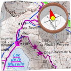
One of MyTrails' most compelling features is its reliance on OpenStreetMap, which provides unparalleled detail and constant updates through its community. This is a game-changer for exploring less-trafficked areas where proprietary maps might lack detail. The ability to download maps for offline use is a critical safety and convenience feature. This ensures uninterrupted navigation even in areas with no cellular reception, a common scenario in many wilderness settings. Map rendering is generally smooth, though complex terrains with multiple layers can sometimes introduce minor delays on older devices. The variety of map types available, from topographic to satellite views, further enhances its utility, allowing users to choose the best visualization for their specific activity and location.
Route Planning and Tracking
MyTrails excels in route creation and execution. Users can either import existing routes or draw their own, with precise control over waypoints and segments. The application provides valuable insights such as estimated distance, elevation gain/loss, and time, which are essential for proper trip planning. During an activity, real-time tracking is accurate, displaying speed, distance covered, and current location on the map. The post-journey review feature is equally impressive, offering detailed analytics of recorded trips, including customizable charts and statistics. This data is invaluable for performance analysis for athletes and meaningful record-keeping for casual users. The inclusion of features such as 'Add GPS Location to Photo Metadata' turns the app into a comprehensive journaling tool for outdoor adventures.
Specialized Features and Community
The app caters to specific niches within outdoor activities. Features like 'Cycling' and 'Running' modes suggest optimized algorithms or display preferences for these activities, though more explicit differentiation in UI or data presentation for these modes would be beneficial. The 'Points of Interest (POI)' functionality is robust, allowing users to discover and categorize important landmarks, water sources, or campsites. The 'Community-based' nature, derived from its OpenStreetMap foundation, means that the map data continually improves, often reflecting ground-level knowledge that corporate maps might miss. While there isn't a direct in-app social community like some fitness apps, the collaborative spirit of OpenStreetMap indirectly serves this purpose.
Performance and Privacy
MyTrails generally performs well, maintaining responsiveness even with complex maps and active tracking. Battery consumption is a critical factor for any navigation app used outdoors, and MyTrails manages this reasonably, especially considering its GPS-intensive operations. Users should still carry a power bank for extended excursions. A significant positive is the 'Privacy focused' approach. In an age of pervasive data collection, MyTrails stands out by offering a functional experience without demanding excessive personal data, which is a strong selling point for privacy-conscious individuals. The 'Ad-free' experience further contributes to a clean and uninterrupted user journey.
Areas for Potential Improvement
While MyTrails is highly capable, there are areas where it could evolve. The user interface, while functional, could benefit from a more modern visual refresh to appeal to a broader audience without compromising its utilitarian strength. While it supports custom workouts, the depth of this feature could be expanded to include more structured training plans. Integration with external sensors (e.g., heart rate monitors, cadence sensors) could elevate its appeal for serious athletes. Some features, like 'Gamification' and 'ZOMBIES' mentioned in the context but not prominently visible or explained in primary documentation, suggest experimental or legacy features that might need clearer integration or removal if not actively developed.
Conclusion
MyTrails stands as a highly competent and reliable outdoor navigation application. Its superior offline mapping, detailed route planning, and strong commitment to user privacy make it an excellent choice for serious outdoor adventurers who prioritize functionality and data control. It may lack the sleek aesthetics or expansive social features of some mainstream apps, but it more than compensates with its robust core capabilities and an ad-free, focused experience. For anyone seeking a dependable tool to explore the wilderness, document their journeys, and maintain privacy, MyTrails is an investment well worth considering.
Screenshots


